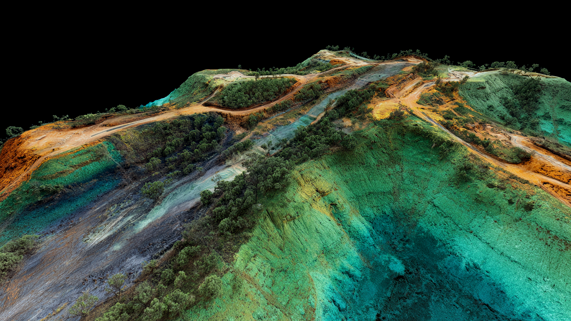
LiDAR Services

Precise LiDAR OG topography for every site

Our LiDAR scans cut through vegetation to capture true ground elevation, reducing rework and delays on every project phase—delivered faster than traditional surveys.
Banner icon

Recipient of the National Association of Home Builders’ Best Software Solution 2024.

Dashboard mockup
LiDAR across industries

LiDAR delivered where work gets done

From oil & gas corridors to disaster recovery and industrial sites, LiDAR gives teams fast, defensible terrain data so they can plan routes, verify grades, and make decisions without waiting on slow topographic workflows. It’s the difference between delays and decisions.

A complete site intelligence solution

TraceAir combines advanced LiDAR with visual data and easy-to-use tools in the TraceAir platform to help teams plan better and execute faster.

Scalable nationwide network

With a coast-to-coast network of FAA-certified pilots, we deliver consistent, professional LiDAR service anywhere your projects take you

Precision delivered fast

Our drone-based LiDAR scans deliver precise original ground data for reliable cut/fill calculations in less than 3 business days

Cost-effective solutions

Leverage advanced technology at highly competitive prices, saving time and budget on your next project.
What is LiDAR?

Laser-accurate ground truth—beyond photos

LiDAR (Light Detection and Ranging) measures distance with laser pulses to produce a highly accurate 3D model of your site. Unlike photos alone, LiDAR penetrates gaps in vegetation and captures true ground elevation—even in messy, real-world conditions.

In practice, that means you can trust your quantities, validate grades, and spot costly issues before they become change orders.
Bare-Earth Surfaces: Strip out vegetation to get the ground you build on.
High-Density Point Clouds: Millions of points = precise contours and volumes.
CAD-Ready Deliverables: Surfaces, breaklines, and contours for Civil 3D & design tools.
Dashboard mockup
Read more

Where LiDAR pays off

Practical ways builders and teams across multiple industries use LiDAR for success.
Work Smarter
5 min read

7 Industries Ditching Traditional Topographic Data for LiDAR

Speed is the difference between delays and decisions. Whether you're breaking ground or rebuilding after disaster, LiDAR gives you the data to move fast and with confidence.
Read post
Work Smarter
4 min read

How LiDAR Gives California Builders a Head Start

Win California land deals with faster site visibility—LiDAR topo strips canopy, reveals terrain, and delivers slope, drainage, and yield clarity in days.
Read post
Work Smarter
5 min read

8 Ways Top Land Developers Use LiDAR to Maximize ROI

Want to avoid costly surprises and stay ahead in every phase of land development? Discover 8 powerful ways top developers use LiDAR to reduce risk, speed up timelines, and maximize ROI—from acquisition to closeout.
Read post

Accelerate your projects with LiDAR

Join thousands of industry experts unlocking the potential of precise LiDAR scans to unveil hidden terrain features, inform design and planning, and streamlining earthwork planning processes.
Dashboard mockup
Answers

FAQs

Your most common LiDAR questions, answered—covering accuracy, file compatibility, delivery speed, and nationwide coverage.
How accurate are TraceAir LiDAR surveys for earthwork, corridor clearances, and as-builts?
We deliver accurate scans to a tenth of a foot (3cm) of bare-earth surfaces suitable for cut/fill, design-vs-as-built checks, and structure/vegetation clearance analysis.
What deliverables do we receive, and will they work with Civil 3D and GIS?
You’ll receive a processed point cloud (LAS) file that's also available inside TraceAir for measuring volumes, overlaying designs, cross-sections, and quick sharing—no specialist required.
How fast is capture and delivery—and what drives timeline/cost?
Turnaround is coordinated to your window and varies by site size, terrain/vegetation, airspace & weather, access, and deliverables (e.g., corridor miles vs. single site). We provide a predictable schedule and itemized estimate after scoping.
Does LiDAR work under trees/brush—and for long linear assets or disaster response?
Yes. LiDAR returns multiple hits through canopy gaps, allowing us to classify/remove vegetation and dense grass to model true ground. The method scales well for linear assets (routing, encroachment & clearance checks) and rapid post-event assessments (storms, fires, floods) when teams need defensible terrain data quickly.
How is TraceAir different from other LiDAR providers?
TraceAir delivers a turnkey LiDAR solution—from flight to data delivery—through our nationwide network of FAA-certified drone professionals and in-house processing experts. Unlike marketplace-style providers that outsource to varying pilots or equipment, we maintain direct quality control, consistent accuracy, and predictable timelines across every region.
Take the next step

Talk to a LiDAR Specialist

Connect with our experts to discuss your site, data needs, and project timing. We’ll help you determine the most efficient, cost-effective LiDAR approach.

Request A Quote